LiDAR Mapping for Precise Indoor Navigation
There are several challenges related to positioning in indoor spaces. Signal attenuation, multipath interference, and limited GPS coverage pose considerable obstacles to precise positioning. LiDAR-based navigation systems offer high-accuracy positioning and obstacle detection to assist with mapping indoor environments and provide reliable navigation data. Additionally, machine learning algorithms can enhance indoor navigation by learning and adapting to user behaviors to improve the overall navigation experience. However, it is crucial to continuously improve and optimize indoor navigation systems by developing mapping databases and algorithms. By addressing these challenges and leveraging these technologies, we can achieve precision navigation in indoor environments and enable seamless user experiences.
The Importance of Effective Indoor Navigation
Efficient indoor navigation systems can enhance the user experience in complex environments. With increased precision, users can save time wasted on searching for specific locations. These systems can also improve safety and security in crowded areas by providing accurate information on emergency exits and evacuation routes. Additionally, seamless movement and easy access to amenities through accurate information are guaranteed. Whether finding a restroom or a conference room, reliable navigation is crucial for optimizing operational efficiency in large spaces. Effective indoor navigation systems are vital to make indoor spaces more accessible and user-friendly.
Common Hurdles
The limited effectiveness and availability of GPS in indoor environments pose a challenge. In complex and dynamic indoor layouts, confusion and disorientation are common. Interference from walls, obstacles, and signal obstructions can also significantly affect accurate positioning. Moreover, floor plan variations and building structures make accurate maps for indoor navigation systems difficult to create. Inconsistent Wi-Fi and Bluetooth connectivity further add to the challenges, often disrupting the smooth functioning of any system implemented. Overcoming these hurdles is crucial to ensure a precise and efficient indoor navigation experience. By addressing the limitations and finding innovative solutions, developers can create more robust indoor navigation systems that provide accurate and reliable guidance to users.
An Introduction to LiDAR Technology
LiDAR technology utilizes lasers and sensors to measure distances and can be used to create detailed 3D maps. A LiDAR system can provide accurate spatial information for high-precision mapping and navigation in various environments by emitting laser pulses and analyzing the reflected light. This technology has revolutionized mapping applications, both outdoors and indoors. LiDAR’s ability to accurately measure and map an environment has made it indispensable to autonomous cars, remote sensing, and mobile mapping. With its varied applications and relevance to future trends, LiDAR has become essential for collecting and analyzing big data for multiple purposes. As the technology advances, with new features such as CMOS sensors and integration with smartphones and mobile devices, LiDAR will further enhance precision navigation and mapping capabilities.
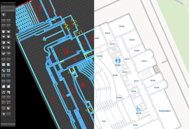
How LiDAR Works for Indoor Mapping
LiDAR scanners utilize light detection and ranging technology to enable precise indoor mapping for navigation purposes. These scanners emit laser pulses that travel through the indoor environment and measure the time it takes for the pulses to bounce back. This data is used to create a 3D point cloud, which represents the spatial information of the surroundings. Advanced algorithms analyze this point cloud and create detailed indoor maps that capture the geometry and spatial relationships of the environment. LiDAR mapping can help deliver precise localization and path planning in the most complex indoor spaces. This technology has become a game-changer, providing accurate and reliable solutions for multiple applications. With the ability to capture detailed imagery and ranging information, LiDAR technology offers a powerful remote sensing method that has proven invaluable in creating indoor mapping solutions.
Advantages of LiDAR Over Traditional Methods
LiDAR technology offers several advantages over other traditional methods of indoor mapping. One of the main advantages is that LiDAR eliminates the need for manual measurements and physical surveying. Which not only saves time but also reduces the chances of human error. Additionally, LiDAR provides a non-intrusive and non-destructive method of capturing indoor spatial data. Another advantage of LiDAR is its higher accuracy and precision. LiDAR’s superior ranging enables precise measurements, even in complex indoor environments. Moreover, LiDAR significantly reduces the time and resources required for indoor mapping projects. With its remote sensing method, LiDAR enables efficient data collection without a need for extensive on-site work. Furthermore, LiDAR technology is future-oriented. As mobile devices become more advanced, LiDAR can be integrated into smartphones and tablets, allowing for real-time indoor mapping and navigation. In conclusion, LiDAR offers numerous advantages over traditional methods, making it a powerful tool for precision indoor mapping and navigation.
An Examination of LiDAR Mapping
LiDAR mapping involves the utilization of LiDAR sensors to collect raw data in indoor environments. This data is converted into a point cloud, which represents the 3D structure of the space. The point cloud data must then undergo processing and analysis to generate a detailed map of the indoor area. Advanced algorithms are utilized to clean, segment, and classify the point cloud data, resulting in an accurate and comprehensive indoor map. The constructed map can be utilized for various applications, including navigation, asset management, and security. By employing LiDAR technology, indoor mapping projects benefit from the ability to collect precise and high-resolution data, offering valuable insights into the indoor environment. As LiDAR technology advances, it holds the potential to revolutionize indoor navigation and enhance the overall user experience.
Navigation, Architectural Design, and Planning
LiDAR-based navigation systems greatly enhance the visitor experience in large venues such as stadiums and convention centers. Additionally, the detailed 3D maps generated by LiDAR contribute to efficient space utilization and optimization, allowing for better planning and design of indoor spaces. Moreover, crucially, LiDAR can support seamless navigation for visually impaired individuals in public buildings and facilities. By providing accurate and real-time data, LiDAR ensures that everyone can navigate through indoor environments with ease and confidence. Integrating LiDAR technology for navigation, architectural design, and planning is revolutionizing how we interact with indoor spaces and improving accessibility for everyone.
The Potential of AI and Machine Learning in LiDAR Processing
AI and machine learning hold immense potential in revolutionizing LiDAR processing for indoor mapping. These advanced algorithms automate LiDAR data processing, leading to faster and more accurate results. Machine learning models are trained on large datasets to extract valuable information from LiDAR point clouds, enabling the identification and categorization of objects within LiDAR scans. This combination of AI and LiDAR has transformed object detection and recognition in complex indoor environments. Furthermore, machine learning techniques facilitate real-time analysis of LiDAR data for navigation and mapping applications. With the integration of AI and machine learning, the future of LiDAR processing for indoor mapping looks promising, offering increased efficiency and precision. As technology evolves, we can expect more innovative uses of AI and machine learning in LiDAR processing.
Integrating LiDAR with Building Information Modeling (BIM) for Improved Results
Integrating LiDAR with Building Information Modeling (BIM) enables better management of building maintenance and energy consumption by identifying areas that require attention and optimization. As an evolving technology, indoor LiDAR mapping continuously offers new opportunities for innovation and development, shaping the future of mapping. The seamless integration between LiDAR and BIM leverages the power of big data, high-resolution imagery, and light detection and ranging to enable detailed and accurate mapping. With the growing importance of remote sensing methods and the rising relevance of indoor mapping, integrating LiDAR with BIM sets the stage for future trends and advancements.
Conclusion
In conclusion, LiDAR technology has revolutionized indoor mapping and precision navigation. Its accuracy, versatility, and ability to map complex environments make it an invaluable tool for various industries. As advancements in LiDAR continue, we can expect to see even more innovative solutions and the integration of AI and machine learning for more efficient data processing. Furthermore, the miniaturization of LiDAR devices and increased automation will further streamline indoor mapping processes and make them more accessible and affordable. With the potential for high-resolution scanning and integration with building information modeling (BIM), the future of LiDAR indoor mapping looks promising. If you’re interested in exploring affordable LiDAR indoor mapping solutions or want to learn more about integrating LiDAR with BIM, contact our team for a consultation. Let us help you navigate the future of precision indoor mapping.